
The Stokesley River Leven Group
Registered Charity Number 1117713
Chairman – Nat Smith
Secretary – Wilf Turnbull
Treasurer –
River Leven
Through Stokesley
PROPOSALS FOR ENHANCEMENT
Page 1 Introduction
The bases for the proposals are the
reports of the surveys by the
The River Leven Group’s overall remit
includes the river between the flood control sluice gates
at the east and west of Stokesley.
This Enhancement Project, however, relates
only to the sections that are within the town area and are readily accessible
to the general public.
Page 2 Notes
Page 3 East Section Details
Page 4 West Section Details
Page 5 Additional Concerns
Page 6 Children
Page 2
Notes
1. All the
numbered items, with the exception of 3, 6, 12, 15 and 17 relate to issues
mentioned in the RRC reports.
2. Items 6 and
12 are considered to be desirable in terms of current legislation on safety;
however they do have historic context that may over-ride such factors.
3. Item 3 is an
on-going maintenance factor. Discussions with the Highways Authority are
needed.
4. Item 15 has
been proved by a Group survey of opinion to be a very desirable feature.
5. Item 17 is a
weir that was built by someone unknown; it is causing exceptional depth at this
point and also causing silt to build.
6. The major
factor of concern is the low level of water running through Stokesley; its
quality can be improved by the measures enumerated but the controlling factor
is the size of sluice upstream. Any change to this would need Environment
Agency collaboration and expenditure of quite a lot of money.
7. Lack of fish
in the river is another concern although recent information suggests that the
residents of the Leven Banks Estate have secured the co-operation of the
Environment Agency in the provision of a fish ladder, or its equivalent, at the
downstream sluice.
8. Maintenance
of the stone work along the river is necessary; inspection and listing is
needed.
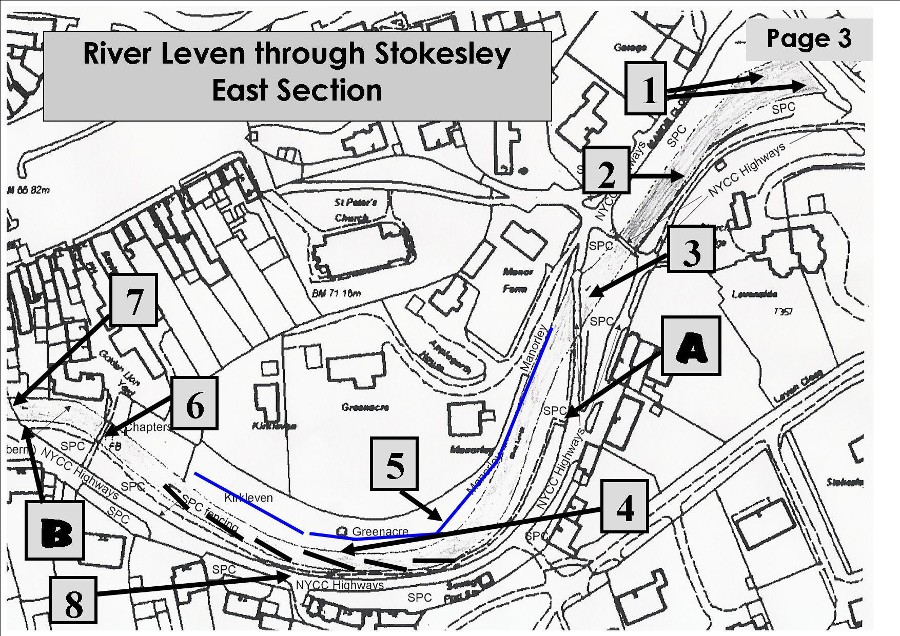
DATA REFERRING TO NUMBERED LOCATIONS IN EAST SECTION
1. Silted areas that have become overgrown with plants and weeds —
could these be developed for play areas with some hard ground cover? The water
channel is quite narrow.
2. In-river
growth along this wall will protect the wall and will be allowed to develop.
3. Traffic Ford — suitable only for 4x4s and
large vehicles. The wash from these is eroding the grass banks. Protection or
vehicle speed control needed.
New dry ford with water
piped beneath???
4. Brushwood fingers need to be installed to
encourage plant growth along banks is needed.
5. Tree
line of riparian landowners that should be kept from over-growing the river.
6. Plank
footbridge — widen, give it handrails? It has historic context.
7. Private concrete ford — causes silt back-up.
Rebuild with piped underpass for water?
8. Trees
along the south bank should not be allowed to overgrow the river as the shade
discourages river plant growth. Assessment needed for early action.
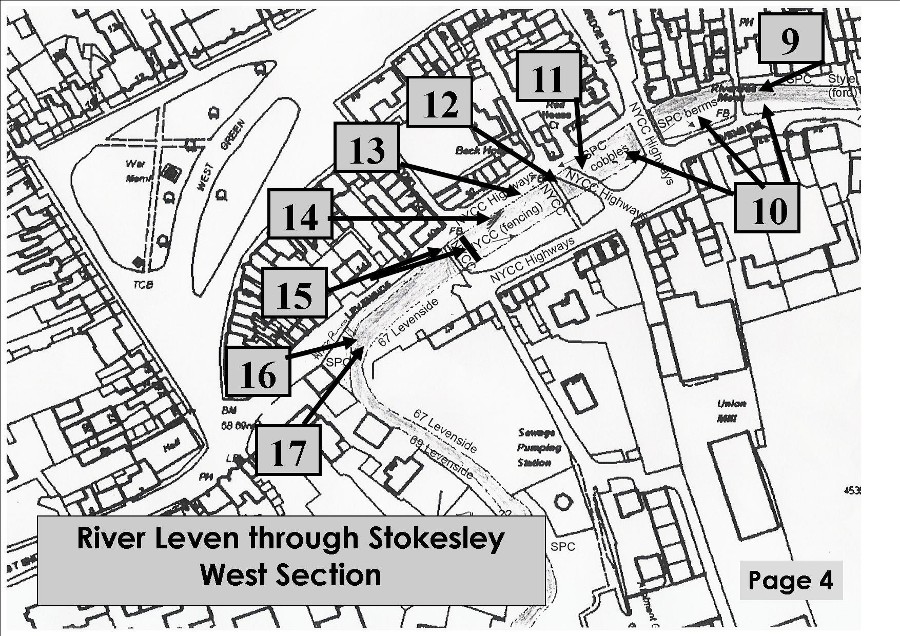
DATA REFERRING TO NUMBERED LOCATIONS IN WEST SECTION
|
9 |
Historic pack-horse bridge. Modify the berm beneath as in 10. |
13 |
Drain outfall that discharges oily waste water.
Install pipe to control the outflow into midstream or downstream between the nearby
sludge bed and river wall. |
|
10 |
River Berms inserted by Parish Council. Modify
the stonework and modify the earth fill for drainage; plant with suitable
plants or pave and insert plants in pockets. Make accessible to the public? |
14 |
Sludge bed. This has
become oily with the drain discharge (13). Re–make or remove in order to form
a new bed using edge stone as the other berms. |
|
11 |
Paved ford, now unused. Remove, breach or reconstruct
with water carried below in pipes. RRC consider that this ford causes silting
up-stream. They would prefer to see a gravel bottom to encourage migrating
fish. |
15 |
Remove existing high footbridge and
replace with new timber bridge to match that at east end. This will
allow easier passage for old people and wheelchairs. (re-align
existing 9” water pipe) |
|
12 |
Concrete plank footbridge — widen, give
it handrails? It has historic context. |
16 |
Consider provision of public
access to a paved area below the existing access steps. |
|
|
|
17 |
Remove all unofficial
weirs. |
ADDITIONAL CONCERNS – RIVERSIDE ASPECTS Page 5
A to B on East
Section. Footpath along Levenside.
1. The footpath was installed by the Parish
Council along the grass verge. It needs re-assessment as it is not really
suitable for the wheeled vehicles used by movement impaired persons. It is too
narrow for mobility vehicles or for two people to walk side-by-side. Along part
of the length the path is very near to the river bank and there is a tendency
for the paving slabs to slip towards the river. Along another section it is
below grass level so that, in wet weather, water pools and prevents use; people
have to climb over the railings beside the road in order to progress. Near
point B the path is so steep that mobility vehicles cannot
really use it. Near item 6, the footbridge, where there is a seat the earth is
mostly bear of grass and is impassable in wet conditions.
2. It should be considered whether the path
is really viable and abandoned or whether some riverbank structural measures
ought to be taken to make path reconstruction viable.
3.
Along the same stretch the river bank is patchy in terms
of natural growth; ducks have many tracks in/out of the stream. Much of the
problem is caused by the lack of sunlight due to the overgrowth of trees on
this south side. Some thought is needed to improve this section’s ambience.
4. Along the grassed riverside of Manor Close
the tubular metal railing mounted in concrete posts is in a deplorable
condition through young people jumping on the tubing; most sections are bent
and a number have to be replaced on a fairly regular basis. The whole railing
should be replaced with the timber variety used with great success elsewhere
along the river. Opposite here, on the south bank, there is similar railing
with rusty tubes – all should be made in timber for uniformity.
Page 6
CHILDREN
Children
in wellies. The Ford at
Location 3 on the East Map is a favourite place for children to
paddle in wellies to seek fish of the tiddler variety. They also make ‘sand’
pies of the soil in this area. At one time they were also able to enjoy this
pastime in the areas 1 and 2. The latter area would be far safer because of the
heavy vehicles that travel through the ford.
There
could be other areas further westward if the berms were to be made more
amenable to use.
It
is uncertain whether wellie activities are very popular in the weir area.
Children
Feeding Ducks A very popular pastime
much frowned on by the RRC because of the attraction of rats to uneaten bread.
RRC recommend warning signs with suggestions for the right kinds of food to
provide.
Children
on Ponies Again, the ford at 3 is a
favourite meeting and crossing place. At one time the crossing place was in
locations 1 and 2 where cattle used to cross.
MORAL The river should be
a natural place for children to enjoy; considerable thought should be given to
this aspect as part of the philosophy for the Enhancement Project.
~~~~~~~~~~~~~~~~~~~~~~~~~~~~~~~~~~~~~~~